Heightmap |
A hightmap is a bitmap that displays the height of every singular vertex on a terrain in pixels. Please find the heightmap of a selected terrain under deform setting within the terrain tab.
First of all let´s have a look at a typical hightmap.
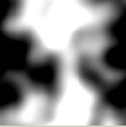
As you can see a hightmap consists only of black and white color mixtures. The secret of the convertion: white stands for the maximum hight of the terrains (in quants) and black for the minimum height. So with this terrain there would be a big mountain in the upper middle which bottoms out to the left and to the right.
If in GED you right click onto the heightmap, a menu appears that allows you to import or export from or into various image formats.